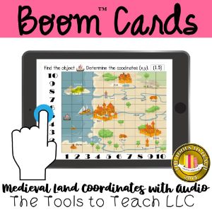
Medieval Land Graphing Map Coordinates with Audio
Price: 300 points or $3 USD
Subjects: cultureAndSociety,math,mathMiddleSchool,midSchoolGeometry,midSchoolGeometryGraphing,graphing,geometry
Grades: 5,6,7
Description: In Medieval Land Map Coordinates, learners move the indicated artifact or object and find it on the grid. Students determine (x,y) in this 25-question, open response math lesson with audio directions. Medieval Land Map Coordinates is randomized or different each lesson! Common Core State Standards 5.G.A.1 Use a pair of perpendicular number lines, called axes, to define a coordinate system, with the intersection of the lines (the origin) arranged to coincide with the 0 on each line and a given point in the plane located by using an ordered pair of numbers, called its coordinates. Understand that the first number indicates how far to travel from the origin in the direction of one axis, and the second number indicates how far to travel in the direction of the second axis, with the convention that the names of the two axes and the coordinates correspond (e.g., 𝘹-axis and 𝘹-coordinate, 𝘺-axis and 𝘺-coordinate). Boom™ Cards is a trademark for Boom Learning. Used with permission.